Planning in Walberton Parish - Current Situation (November 2023)
Overview
The Parish is currently host to a number of active building projects for quite a number of houses. It feels as if large parts of our neighbourhood are just a building site with the associated disruption this brings. The Fontwell Meadows and Avisford Grange estates are very well into their builds; the estate on the land to the West of Tye Lane is just beginning construction.
Why is our Parish being swamped by houses? Arun District Council is required by the Government to demonstrate a deliverable supply of new homes to meet the planned housing requirement over the next 5 years. Unfortunately, Arun has only been able to show less than 3 years’ supply. This fact has been used by developers to argue for sites to be granted permission for development. In many cases, even though the Parish Council has objected to sites and Arun has refused permission for them to go ahead, they have been overruled by the Planning Inspectorate with reference to this land supply issue. In some verdicts, reference has been made to the fact that the sites are not particularly ideal, but that the housing quota issue has been the deciding factor.
Walberton Parish has a Neighbourhood Plan. This consists of, among other things, a set of sites which have been reviewed independently to confirm suitability to contribute towards the Parish’s allocated quote of houses. These are sites on which we will support development provided that the application contains a sensible and sustainable proposition. The vast majority of large-scale applications that we are seeing are for sites that are not part of our Plan and on principle we will object to these.
While some may consider our objection to large-scale building to be NIMBYist, we are grateful for the support of many of our residents in trying to protect the distinct nature of our Parish. There are a number of issues which, in our opinion, make it inappropriate for further developments at this time and we will continue to reassert these in our representations. These include
- The lack of school places. West Sussex as a whole now has no further capacity, and our local schools are full. We consider bussing children long distances to find places not to be a sustainable approach.
- The lack of healthcare facilities. The Parish lacks any local medical services.
- Drainage and the lack of sewerage capacity. Our Parish has a number of locations prone to flooding. Southern Water has been a regular feature of news reports concerning its lack of capacity to deal with the current level of sewage let alone that from hundreds more houses.
- The lack of transport infrastructure. Developers regularly state that walking and cycling are sustainable methods of transport, but many of our roads have limited or no footway and cycle routes share the main carriageway. Public transport is very limited, necessitating car transport to access places of work and this increases the traffic and pollution levels on our minor roads.
An overview map of the current state of play for planning applications.
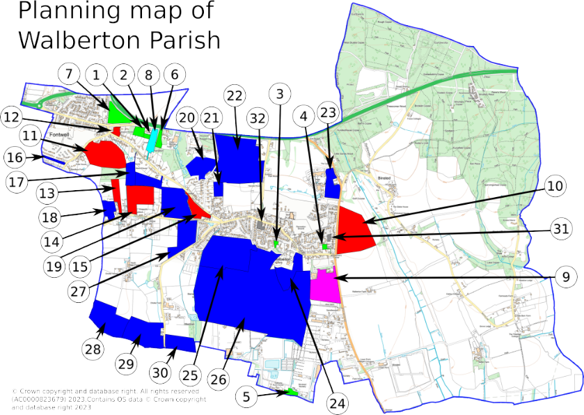
The sites shown are divided into several colour-coded categories.
Neighbourhood Plan sites (green)
The following sites are all part of our Neighbourhood Plan with no active planning applications attached to them.
- HP3: S&G Motors. A brownfield site to provide up to 28 dwellings.
- HP4: Land at the rear of Woodacre. 2 dwellings, accessed via site 1.
- HP14: Dower House. Approximately 6 dwellings.
- HP15: Longwall. Approximately 3 dwellings.
- HP16: Sussex Business Park. A brownfield site to provide approximately 11 dwellings.
- HP17: Gracelands Farm. 2 dwellings.
- HP18: Fontwell Field. Approximately 40 dwellings.
Active applications
There is currently one site that is part of the Neighbourhood Plan where construction started last year. This is coloured cyan.
- HP5: Woodcroft. 8 dwellings with access from Arundel Road.
There are a number of other applications which are active.
- Land West of Yapton Lane (magenta) - application WA/2/22/OUT. This site was refused permission by Arun but this was overturned at appeal by the Planning Inspectorate. It is a site for up to 48 dwellings.
- Land East of Yapton Lane (red) - WA/80/21/OUT. This site has been refused permission by Arun but has an appeal currently in progress. No date for the decision has been announced.
- Land East of Wandleys Lane (red) - WA/35/23/OUT. This application is for up to 95 dwellings between Wandleys Lane, Wandleys Copse and West Walberton Lane. The Parish Council objected and it is due to be debated by Arun’s Planning Committee in the middle of January.
- Land at Lane’s End, West Walberton Lane (red) - WA/14/23/PL. This is an application for 6 dwellings. It was previously refused permission by Arun in 2020 and the re-application was also recently refused. It may go to appeal or there may be a further revised application on this site in future.
- Cherry Tree Nursery, Eastergate Lane (red) - WA/39/22/PL. This recently had the refusal of retrospective permission for 14 caravans overturned by the Planning Inspectorate. The site has been put forward for consideration for development so further applications for more permanent buildings may result.
- Brookfield Farm, Eastergate Lane (red) - WA/101/22/PL. The application for 2 houses was refused by Arun at the beginning of the year. It is currently under appeal.
- Land at West Walberton Lane (red) - WA/67/23/PL. This application for 25 houses is a resubmission following refusal for permission at appeal for 30 houses on this site in 2022.
Other sites (blue)
These sites have been promoted by landowners and developers to Arun District Council as part of their calls for new sites for development but for which there are currently no planning applications. Some sites are considered more usable than others and we may see applications for development on these at some stage. We will be monitoring these.
- Arun House, Wandleys Lane. Although this is listed by Arun as not developable due to its distance from other key sites, the completion of the Fontwell Meadows estate may lead to development this site becoming more feasible.
- Land to the rear of The Pines, West Walberton Lane. This is currently considered by Arun to be less suitable for development.
- Land at Freeman Close, Eastergate Lane. This is promoted as a redevelopment of the site for 30 dwellings related to care provision and older people’s housing but the site is currently not available due to tenants at the existing properties.
- Land to the North of Eastergate Lane. This has been promoted for the construction of 150 dwellings, but is currently considered not suitable for development by Arun.
- Remaining land at Sunny Corner. Arun lists this plot as unsuitable for development due to the ancient woodland and drainage issues.
- Land to the rear of Woodlands, Cresta. This plot is currently considered unsuitable for development by Arun due to the lack of access. However, now that the large site to the west of Tye Lane has been granted permission at appeal, the access issue may change.
- Land at Hooe Farm. This site is currently considered to be unsuitable as the A27 Arundel Bypass may yet run right through it. However, this may change depending on what happens with the A27.
- Land West of Yapton Lane, near Avisford Park Hotel. This site has been promoted for up to 55 dwellings. The A27 Arundel Bypass route may have an impact on whether or not this site is viable.
- Walberton House. This location has been promoted for 5 dwellings but is currently considered unsuitable by Arun due to its historic surroundings and protected trees.
- Land south of Walberton. This has been considered unsuitable by Arun for large-scale development as it is within the Walberton-Barnham gap.
- Pigeon House Farm and land to the South. This piece of land has been considered unsuitable by Arun as it is within the Walberton-Barnham gap with a low landscape capacity for development.
- Choller Estate: Land south of Eastergate Lane. This location has been promoted for 125 dwellings and is currently considered by Arun due to its location and impact on the countryside.
- Choller Estate: Land north of Elm Grove, Barnham. This plot is within the Choller Estate and has been declared surplus to requirements by West Sussex County Council. It has been promoted for 140 dwellings but is considered unsuitable by Arun due to its location in the Walberton-Barnham gap and lack of access, though this may change if the neighbouring plot is developed.
- Choller Estate: land to the north and west. This has also been promoted for 150 dwellings and is currently considered unsuitable by Arun as it would interfere with the Walberton-Barnham gap.
- Land east of Barnham Lane (Nanny’s Copse). This site extends into Barnham & Eastergate Parish. It is not currently considered suitable by Arun as part is in the Walberton-Barnham gap and the rest is in protected Local Green Space.
Inactive sites (grey)
The final two sites have been previously promoted but are no longer being actively considered. They still appear on Arun’s development maps.
- Land at the rear of Nyefield. This site was previously promoted but has now been withdrawn. It still appears on the Arun maps.
- Branlea, Cisbury and Lansdown House. Although this site has been put forward to Arun in the past, it is currently not being put forward for development.